
ABEL TASMAN INLAND TRACK
The second option behind the wake of the Coastal Track is the 41.1 km long Abel Tasman Inland Track, which runs inside the park.
- It starts from the Coastal Track, with three entry points: Tinline Bay, in Anchorage Bay area, and there is also an entrance near Cleopatra’s Pool. It ends at Wainui Bay, so it starts and ends in the same areas as the Coastal Track.
- By not offering views of the coast, it is much less popular, and therefore we can enjoy the forest with fewer people around us, but it is also harder.
- There are 3 huts on the route, they are free and have latrines and untreated water, but they cannot be booked and are quite small, the largest is Awapoto and it only has capacity for 24 people.
- We have to carry all our food and garbage.
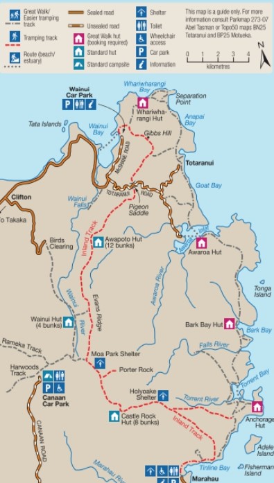
Official map of New Zealand Parks Conservation Department showing the Inland Track in red. Gibbs Hill and Wainui Falls also appear on the top, and Harwoods Track on the lower leftFrom this trail I only hiked a short optional section that connects Cleopatra’s Pool area southbound with the Coastal Track, but without going through Anchorage Bay, and both the vegetation and the views are spectacular.

Although we miss sight of the coast, the forest is extraordinary
Brutal tree ferns over 10 meters highThree stages are usually performed, and therefore it usually takes three days:
- Marahau to Castle Rock Hut, 5h 30min, 15.1 km. From Marahau you have to start the Abel Tasman Coast Track to Tinline Bay where the Inland Track begins. It is much steeper than the Coastal and dense forests predominate. After 2 hours and 30 minutes we will arrive at Holyoake Clearing, where there is an emergency shelter. At this point we will see a path to the right, which leads to the connection with Cleopatra’s Pool and Anchorage. Continue the forest to Castle Rock hut (8 bunk beds), overlooking Tasman Bay.
- Castle Rock Hut to Awapoto Hut, 6h, 13 km. The road deviates to the northwest with an intense ascent 400 meters level up. There is an optional path, the Porter Rock, a granitic ledge with good views, is the highest point on the trail. Descend briefly to Moa Park Shelter (2 hours, 3.5 km here). From here we can go to Rameka or Harwoods trails if we turn west. From Moa Park Shelter the road goes back into thick forest and deflects to the north. If we have made several optional roads and we are running late, or we decide not to continue for any reason, on a short detour to the west is the Wainui Hut (4 bunk beds). If we continue, a sharp descent to Awapoto Hut (12 bunk beds) begins.
- Awapoto Hut to Pigeon Saddle, 3h, 5km, and from there to Wainui car park (2h 25min, 8 km). After Awopoto the road continues to descend progressively until it crosses the road that connects Wainui with Totaranui. From there it goes up a bit until it links with the first part of the Gibbs Hill Track.
Some combine the Inland with the Coastal Track, in a circular route of approximately one week.
GIBBS HILL TRACK
Connect Wainui with Totaranui without following the Coastal Track, through the forest and up Gibbs Hill (382 meters above sea level), which is said to offer the best views of the entire park. It is therefore, in addition to a day trip, an alternative to the last stage of the Coastal Track. Given the slope it is considered an advanced trek. The complete route also considers the return. We can return by the road and in this way the total is 23 km (it is recommended to do it clockwise), or go and return by the path, 18 km.
Both ends of the route are connected by a dirt road.
HARWOODS HOLE
The largest chasm in New Zealand is 3 km westbound from Canaan car park. It takes about 90 minutes round trip. The edge is 50 meters in circumference and the fall is 183 meters, and there are no barriers, so watch out. The car park can be reached by 11 km of dirt road; there is also a camping area with water and toilets.
TOTARANUI
In Totaranui there are several short tours, between 30 minutes to 2 hours long:
- Pukatea walk, 30 min, 0.8 km.
- Headlands Track, 1 hr, 1.6 km.
- Anapai Bay, 2 hr return, 4.2 km. It is the section of the Coastal Track to Separation Point, considered the most beautiful.
WAINUI FALLS
Wainui Falls, 3.5 km south of Wainui after a simple tour. It is a popular picnic area and there are usually groups and families in summer.
ACCOMMODATION AND WHERE TO EAT
MORE ACTIVITIES IN ABEL TASMAN NATIONAL PARK:
<ABEL TASMAN COASTAL TRACK
KAYAK, MOUNTAIN BIKE, HUNTING AND CAMPING>
∇ Destinations / ∇ Oceania / ∇ New Zealand / ∇ South Island / ∇ Abel Tasman National Park

Pingback: EL INLAND TRACK Y OTRAS RUTAS DE SENDERISMO EN EL PARQUE NACIONAL ABEL TASMAN – Al Was Here
Pingback: ABEL TASMAN COASTAL TRACK – Al Was Here
Pingback: KAYAKING, MOUNTAIN BIKE, HUNTING AND CAMPING IN ABEL TASMAN NATIONAL PARK – Al Was Here
Pingback: WHERE TO EAT AND SLEEP IN ABEL TASMAN NATIONAL PARK – Al Was Here
Pingback: ABEL TASMAN NATIONAL PARK TRAVEL TIPS: WHAT TO PACK – Al Was Here
Pingback: ABEL TASMAN NATIONAL PARK – Al Was Here