
The Abel Tasman Coastal Track is a 60 km long route that runs along Abel Tasman National Park‘s coast from Marahau to the south, to Wainui to the north. It is one of the 9 Great Routes of New Zealand and boasts of being the most popular in the country.
As the name implies, most of the time we will not lose sight of the coast, which makes it special, since we can enjoy landscapes of beach and rain forest at the same time. Being coastal, the gap is not relevant, so it is considered easy level. In addition, in case we are tired or unable to do it whole, some parts can be done by kayak or water taxi. It usually takes 3 to 5 days. There are 4 huts and 18 campsites, that must be booked in advance.
STAGES
There are some pre-established stages, but the presence of multiple camps along the trail means that we can customize them according to our interest. In fact, myself, that I was only there one day, and very, very regretful that I had not stayed any longer, I made a mix: I took a water taxi from Kaiteriteri to Torrent Bay and returned south, going through the Cascade Falls, Cleopatra’s Pool, start of the Inland Track until its connection with the Coastal Track and Marahau, in total 16.1 km.

You can be sure it took me much longer than 3h 28min suggested by Google Maps
The usual stages are as follows:
- Marahau to Anchorage. 12,4 km, 4 hours approximately. Start at Sandy Bay, which is just Marahau River estuary. We will pass through several small bays and we can see the Fisherman and Adele islands as well as the coast from multiple viewpoints. There are 8 camps and a hut. Anchorage beach is perhaps the prettiest and widest of the route.

Apple Tree Bay under heavy rain

A stream near the trail

View of Anchorage Bay
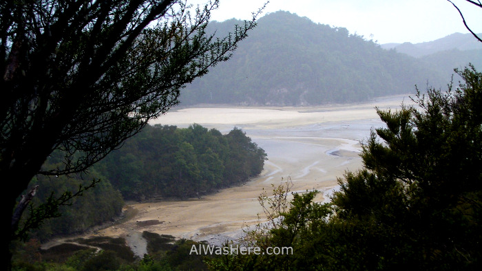
- Anchorage to Bark Bay. There are two options depending on the tide, the High Tide Track (11.5 km, 4 hours), or the Low Tide Track (8.4 km, 3 hours), which crosses the estuary of Torrent Bay. In this part is one of the most popular optional tracks, the Cleopatra’s Pool, just have to deviate 400 meters. There is also another optional route that in my opinion is not worth it, it is 1 hour 30 minutes round trip to the Cascade Falls. Torrent Bay Estuary is beautiful at low tide. One of the highlights is a 47-meter suspension bridge over the Falls River. In Torrent Bay there is a campsite, and in Bark Bay there is a campsite and a hut.
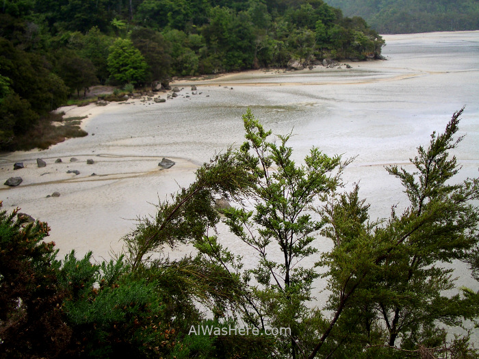
Torrent Bay estuary view from High Tidal Track

The detour to Cleopatra's Pool

Cleopatra's Pool, a beautiful spot for swimming in good weather. Is bigger than it looks on the picture, people usually sit where the tiny waterfall and slide to the right like on a toboggan

At some points we may not see the coast being this thick the forest
At some others we'll see the inlet again

Just to go back into one of the most lush forests we have seen in our lives

There I am with the Cascade Falls. While the waterfall is no big deal, the path is beautiful and almost nobody goes there; in an hour or a half that it took me, I didn't find a single person

More areas of thick forest before reaching Torrent Bay

In the park, and in this particular section abound all kinds of ferns, to highlight the famous white ferns, symbol of New Zealand

This fern measured more than 3 meters in diameter. It seemed that at any moment a diplodocus would come out to eat it

And tree ferns, as big as any palm tree
- Bark Bay to Awaroa, 13,5 km, 4h 30m. You pass through the beautiful Onetahuti beach, in front of which is Tonga Island, a seal breeding colony, where is not allowed to access but can be approached by kayak. It ends in the brutal (good weather through) Awaroa beach. On the way there are 3 campsites, a hut and at least one guesthouse. Almost half of the route does not offer views of the coast.
- Awaroa to Whariwharangi Bay. 17 km, 5 hours. Awaroa Inlet is a beautiful place over two kilometers in length, where shallow sandbanks mix with the water, reminiscent of the extraordinary Whiteheaven Beach in Australia, and being in the neighboring country or in a Caribbean island is likely to had enjoyed great fame. It can be crossed in a straight line, just one kilometer through wet sand, but it must be crossed at very low tide, which means a time interval of just around 3 hours, this is 90 minutes before the tide is at a minimum and 2 hours before it starts to rise; those who make the route will have tide tables in all camps and huts according to the time of year. The road alternates interior areas with sections on the golden sands of the coves.
- In case of having to wait for a long time the crossing at low tide, there are those who divide this stage in two. Some only reach Totaranui (7 km, about 2 hours). From Totaranui there is also the option to continue on the Gibbs Hill Track instead of continuing the Coastal Track. Totaranui is also the last stop of water taxis, so if we continue further north there will be fewer walkers.
- Others reach Whariwharangi Bay, where from Totaranui is 9.8 km more, about 3 hours.
- The last stage is the shortest, from Whariwharangi to Wainui Bay; it’s just 2 more hours, 5.7 km. Wainui Inlet y is not part of the track, but if there is low tide it can be crossed between two hours before and two hours after the lowest tide point.
ACCOMMODATION AND WHERE TO EAT
MORE ACTIVITIES IN ABEL TASMAN NATIONAL PARK:
<INLAND TRACK OTHER HIKING TRAILS
MOUNTAIN BIKE, KAYAK, HUNTING AND CAMPING>
∇ Destinations / ∇ Oceania / ∇ New Zealand / ∇ South Island Sur / ∇ Abel Tasman National Park

Pingback: EL ABEL TASMAN COASTAL TRACK – Al Was Here
Pingback: ABEL TASMAN NATIONAL PARK – Al Was Here
Pingback: TRANSPORTATION IN ABEL TASMAN NATIONAL PARK – Al Was Here
Pingback: ABEL TASMAN NATIONAL PARK TRAVEL TIPS: WHAT TO PACK – Al Was Here
Pingback: WHERE TO EAT AND SLEEP IN ABEL TASMAN NATIONAL PARK – Al Was Here
Pingback: KAYAKING, MOUNTAIN BIKE, HUNTING AND CAMPING IN ABEL TASMAN NATIONAL PARK – Al Was Here
Pingback: ABEL TASMAN INLAND TRACK AND OTHER MINOR HIKING TRAILS IN ABEL TASMAN NATIONAL PARK – Al Was Here
Pingback: ABEL TASMAN NATIONAL PARK: SITUATION, PRICE AND PERMITS – Al Was Here
Pingback: ABEL TASMAN NATIONAL PARK: WEATHER AND WHEN TO GO – Al Was Here