The first thing to keep in mind before coming and during our stay in Kirishima is that, given its intense volcanic activity, as of April 2019 there are stretches of the main trails closed to hikers: those that pass less than 1 km from Ioyama volcano crater, and those that pass less than 2 km from Shinmoedake volcano crater.
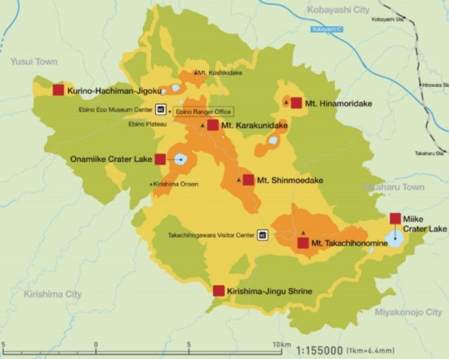
EBINO KOGEN CIRCUIT
Very popular for its landscapes and its scarce difficulty, this flat and circular 4 km route passes next to several volcanic lakes; currently a part is shut, so it is almost linear. The first we will find is Byakushi, about 200 meters in diameter; the next one is Rokkannon Mi-ike, something bigger. The third, much smaller, but of thermal nature is Fudō-ike, but at the moment we will not be able to visit it, since it is in the zone of exclusion because of the small volcano Ioyama activity; in fact, we can not go around Rokkannon either, at a point the road is cut and we must go back to Ebino Kogen.
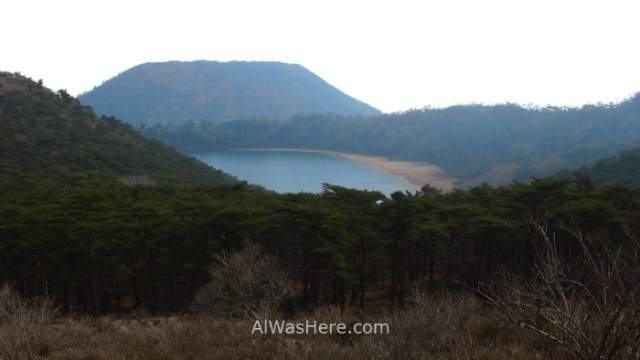
From here we can go south to the most beautiful and biggest, Lake Onami; go, walk around it and go back is almost 8 km more. At the moment there are at least two routes in wikiloc carried out by users that cross the zone of exclusion widely, reason why I do not recommend them; Apart from the danger from the volcano, if they catch us, in Japan fines are not cheap.


It is currently also in the exclusion zone of the Ioyama, but should it improve, if we intend to climb the highest mountain in the region, the Karakunidake (1700m), our only option would be through a trail that begins northeast of Lake Onami, since the usual path, the Kirishima Ridge Trail, is cut. It is steep, it would take about 90 minutes to climb and the same to go down.


In this area the forest is mainly pine, but we will find some Japanese red cedars, although younger and smaller than those in Yakushima. It is very likely that we will see deer and other animals. The top of Karakunidake is as expected, deserted.

KIRISHIMA RIDGE TRAIL
With 12 kilometers in length and continuous ups and downs, it used to be the main route, and it takes, or it took when it was fully open, about 6 hours to complete. Most of it runs along the theoretical border between Kagoshima and Miyazaki Prefectures. It starts at Ebino Kogen, and may or may not include Byakushi and Rokkannon Mi-ike lakes, climb to the top of Mount Ioyama, from there it goes to Karakunidake; It continues in a southeasterly direction to the top of the most famous, Shinmoedake volcano, which appeared in the James Bond movie “You Only Live Twice”. Continue to the top of Nakadake volcano and end at Takachiho-gawara Visitors Center.

As we have already said, Ioyama and Shinmoedake volcanoes are active and have an exclusion zone of 1 and 2 km respectively. That means that from 2011 to today, as of April 2019, the main trail is cut and we can only hike two disconnected segments, the northwestern and the end in the eastern, but we can not even go up to Nakadake from the Visitors Center.
TAKACHIHO NO MINE MOUNTAIN
The ultra-sacred Mount Takachiho, where Japanese mythology believes that Ninigi no Mikoto, grandson of the Sun Goddess Amaterasu, descended to earth to found the dynasty of emperors that in Japan still reigns, is the other popular route of the Park for mystical – religious reasons. The route begins at Takachiho-gawara Visitor Center and is linear to the top, where there is a spear that recreates that supposed to be nailed there by the gods at the exact spot where Ninigi descended. The volcano is predominantly red and there is hardly any vegetation. It takes about 90 minutes to climb to the top. You can continue on a path to the east, but there is no public transport back until we reach Takaharu, where there’s a train station, almost 12 km away from the top.
I did not walk this part, since I depended on the bus, considering that the day before I had to carry my big backpack 10 km uphill, it did not seem so interesting as to dedicate another day to the Park. In the following wikiloc link is the route of a recent round trip ascent of a user:
https://es.wikiloc.com/rutas-senderismo/2018-05-03-mont-takachionomine-30991985
When Kirishima Ridge Trail was open, both routes could be completed in a long day, with an approximate total length of 28 km.
MORE ON KIRISHIMA NATIONAL PARK:
WHEN TO GO, TRANSPORTATION, WHERE TO EAT AND SLEEP (ONSENS) AND HAZARDS>
∇ Destinations / ∇ Asia / ∇ Japan / ∇ Kagoshima and Miyazaki Prefectures / ∇ Kirishima National Park

Pingback: KIRISHIMA NATIONAL PARK – Al Was Here
Pingback: ESSENTIAL INFORMATION IN KYUSHU: WHEN TO GO, DANGERS AND ANNOYANCES, TRANSPORT – Al Was Here
Pingback: KIRISHIMA NATIONAL PARK: WHEN TO GO, TRANSPORTATION, WHERE TO EAT, SLEEP AND GO TO THE ONSENS, AND DANGERS – Al Was Here