Arakawa trail starts at a branch of the road that comes from Anbo before getting to Yakusugi Land, there are restrictions to access in high season (see TRANSPORTATION IN YAKUSHIMA). In my case, I connected with this path after touring the Shiratani Unsuikyo. It took me approximately 2 hours to get to the connection, carrying a 10 kg backpack.

Unfortunately, when choosing this route I missed the first part of the trail, which has a point of interest, the old abandoned lumber town of Kosugidana, but you can not walk everywhere…
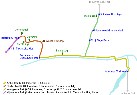
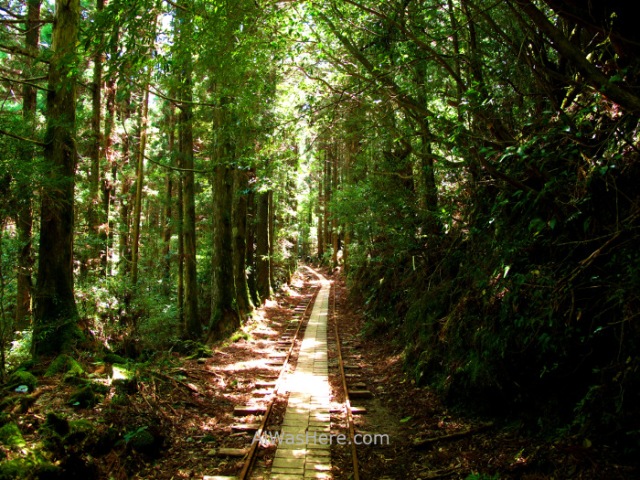
Most of the trail runs along the old restored railway tracks, a total of 8 km from the start of the trail (Arakawa Tozanguchi) and turned into a path, or about 3 km from the connection with Shiratani Unsuikyo; it kind of charming. I spotted deer, and although the monkeys are supposed to abound, I did not see any.


Very close to the end of the railway there is a detour through a wooden staircase, which is the beginning of the Ohokabu Trail. The path becomes very steep as we continue, there are sections of wooden stairs in good condition.


An exciting place is Wilson Stump, a gigantic hollow stump of 32 meters in circumference (double that of the current major in all Japan, the famous Jomonsugi), whose interior is bigger than the bedroom of a house, in which it has even been placed a small altar. It is estimated that the tree, cut 400 years ago, should measure about 45 meters high, which would make it the highest on the island, and had an age of 3,000 years. If you look up from inside, you can see a heart shape, detail that I did not know when I was there.

The route continues very uphill, mostly on stairs and wooden boards, passing by several huge cedars.

But all are eclipsed by the desire to reach the Jomonsugi. This tree is the oldest and largest on the island, and although its exact age could not be determined by the need for aggressive methods to know it, it is very likely that it will be determined soon, since this forest elder died a few years ago, although luckily decades will pass until its trunk disappears. It is estimated to be between 2,200 and 7,000 years old. Its ashen color in comparison to the other cedars back in 2013 seemed to presage its imminent death, the others are covered in moss and other trees, which do not survive in a trunk without life. The tree is protected by a fence and the public is not allowed to approach, which is disappointing, since after having seen so many magnificent cedars from so close, from 20 meters the Jomonsugi does not seem that big.

Most visitors will start the way back. It takes at least 9 hours to get to the Jomonsugi and back. We will continue uphill to one of the two mountain huts, the Takatsuka (restored in 2013, capacity 20 people), very close to the Jomonsugi, or the newest, largest and most remote Shin Takatsuka (1 km from the previous, capacity 40 people), in which I stayed, since the first one was full. Both are wooden and basic; camp stoves are allowed. Staying in one of these shelters guarantees having photos of the tree without the bulk of tourists, who are concentrated at noon and early afternoon, since at that time they still have at least 4 hours on the way back. In mid-April the temperature up there was 0ºC.

The next day I continued the route to the top of Mount Miyanoura. The section is complex, very steep, sometimes requiring the use of ropes to continue. After this peak, the path continues on the ridge to some more peaks, among them the tops of mounts Kurio, Okina and Anbo. A short distance from the main road there are detours to the tops of the Kuromi and Nageshi mounts.


Once we pass the last peak, there are three possible ways down:
- To the east, the Ishizuka trail, which leads to the refuge of the same name and connects to Yakusugi Land.
- To the south, Yudomari path, which leads to the town of the same name on the coast.
- And to the southeast, Yodogawa trail, the one I took, to the hut of the same name.
In this area there are no large trees and although it is beautiful, it is somewhat monotonous compared to the rest of the route.


When arriving at the hut we have two possibilities:
- To the south, Onoaida trail, to the town of the same name, on the south coast, famous for its hot springs. It is the most logical and usual continuation of the route, and the one made by the majority of hikers.
- Or continue on the road, what I did. I thought I had had enough forest, especially when I was going to Yakusugi Land the next day. Next to the road there are several large yakusugis. After about an hour of walking from the hut, we will arrive at Kigensugi, one of the oldest and most impressive cedars of the island, which we already refer to in the Yakusugi Land section. From here I took the bus back to Miyanoura.

MORE HIKING IN YAKUSHIMA:
<SHIRATANI UNSUIKYO YAKUSUGI LAND>
∇ Destinations / ∇ Asia / ∇ Japan / ∇ Kyushu / ∇ Kagoshima/ ∇ Yakushima

Pingback: YAKUSHIMA: ARAKAWA TRAIL – JOMONSUGI – MONTE MIYANOURA – YODOGAWA TRAIL – Al Was Here
Pingback: SHIRATANI UNSUIKYO – Al Was Here
Pingback: TRANSPORT IN YAKUSHIMA – Al Was Here
Pingback: YAKUSHIMA – Al Was Here
Pingback: YAKUSUGI LAND – Al Was Here
Pingback: YAKUSHIMA HIKING TRAILS: YAKUSUGI LAND, SHIRATANI UNSUIKYO AND ARAKAWA TRAIL (JOMONSUGI) – Al Was Here
Pingback: YAKUSHIMA (屋久島) – Al Was Here
Pingback: ESSENTIAL INFORMATION IN KYUSHU: WHEN TO GO, DANGERS AND ANNOYANCES, TRANSPORT – Al Was Here