THE ROUTES
HIKING
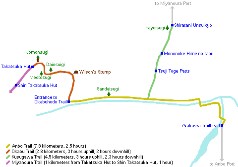
Being a conical island, there are several paths that go from the coast to the interior; subsequently there is a circular path that connects the end of the following:
- Miyanoura: road to Shiratani Unsuikyo, which connects with the circular route of Arakawa Trail on a stretch of railway tracks. From the neighboring Kasugawa you can make the trail avoiding much of the road.
- From Anbo, the road gets to the beginning of Arakawa Trail, further on to Yakusugi Land, which connects to the former and even further on to the Kigensugi and Yodogawa mountain hut. There is an alternative parallel trail that passes through Ishizuka hut.
- From the south, from Onoaida there is a trail that goes to Yodogawa hut, and from Yudomari there is another one that connects a little higher to the circular one, but the first section is paved road.
- From the west there are two trails, both with an initial stretch of road. The first leaves Nagata; the second goes to the main circular road, several kilometers north of Kurio, the nearest town.
The official map of the hiking trails of the island from Yakushima Tourist Office can be downloaded at this link.
What I did: Shiratani Unsuikyo, Arakawa Trail to the Jomonsugi, Shin Takatsuka hut, Mount Miyanoura, went downhill to Yodogawa hut and finally I walked to the Kigensugi, where I took the bus. The next day I went to Yakusugi Land.
YAKUSUGI LAND
It is one of the most popular trails in Yakushima, for being relatively flat and simple and have a large number of yakusugis in it, also close, although not on the route, one of the largest and oldest, the Kigensugi. It is accessed from Anbo road, by private vehicle or by bus. You have to change at the entrance of Yakusugi Museum, which has information about these trees and which I personally did not visit (admission 600 ¥, open from 9 am to 5 pm).

Open from 9 am to 5 pm, suggested donation 300 ¥. It has 4 routes of different length and difficulty:
- The 30 (800 meters) and 50 (1.2 km) minutes courses are basically flat and in some sections you walk on boards.
- Those of 80 (2 km) and 150 (3 km) minutes are steeper, in some areas there are stairs.

For me, Yakusugi Land was the icing on the cake. I started my two-day route at the Shiratani Unsuikyo, reached the Jomonsugi and slept in a mountain shelter near the top of the Mount Miyanoura. I went down south, but instead of continuing to the coast as most hikers do, I veered east, connecting to Kigensugi road, so I arrived at Yakusugi Land relatively late and tired, so I decided to go to rest and return the next day with plenty of time, without an 11 kg backpack on my back.
Following the official map, the route begins at point (1) and ends at (15). The trails are all circular, with the shortest included in the course of the longest.
Before reaching the first famous cedars, we will pass under the trunk of this one.

We will continue through a beautiful and green forest.

A few minutes later we arrived at the first cedar with its own name, the Sennensugi (4), whose name means “a thousand years old cedar”, which agrees with its “young” age.

Those who want to hike the 800-meter route, should turn left at the next intersection. The rest will continue to reach a suspension bridge, the Arakawabashi (5). Before crossing it there is a detour to the left for those who hike the 1.2 km route. If we continue, just 120 meters further on is the detour to the left for the 2 km route. If we have not taken any detour, we will continue along the 3 km route. Take into account that the two longest routes run through steep areas and require a certain physical shape. In this area there are enough cedars, some with their own name, and others that without having it were in my opinion more beautiful; following the route are cedar trees Higchoro (6), Jamonsugi (7) (not to be confused with the famous Jomonsugi) and Tenchusugi (8).

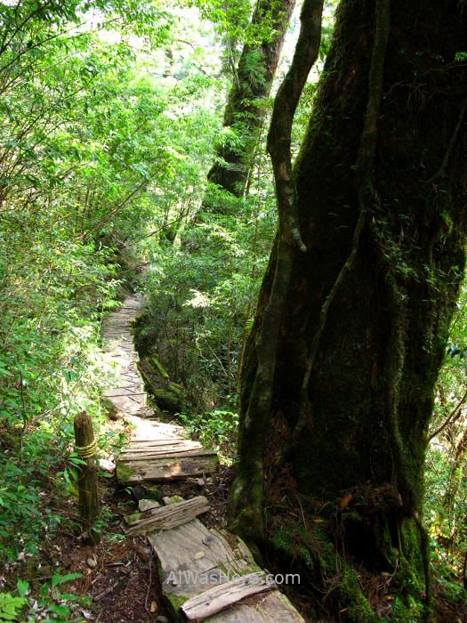
In this area there are fewer tourists, so it is the quietest and most peaceful.

Then there is the Oyakosugi (9), whose name means “mother and son”, one of the most beautiful by having two trunks, each of 2,600 years old and circumferences of 9 and 6.3 meters, although one is dead. Immediately afterwards we found the Mitsunesugi (10), which is another example of a tree that remains on “legs”, after the stump on which it grew has disappeared.


About 500 meters from the above is perhaps the most attractive of the Yakusugis in this area, the Butsudasugi or “Cedar Buddha”, for its large number of knots and folds in the bark and being hollow, 1,800 years old.

The last ones are the Futagosugi (13) and more peculiar, the Kugurisugi (14), which has two very well defined trunks under which the road passes.


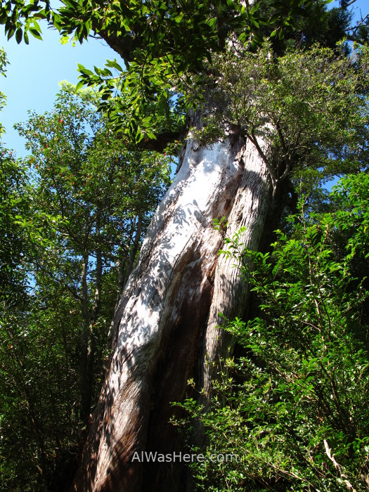
If we are more into to see cedars, about 15 – 20 minutes by car or public transport to the west, right next to the road, is the Kigensugi, one of the oldest, 3,000 years old.

SHIRATANI UNSUIKYO
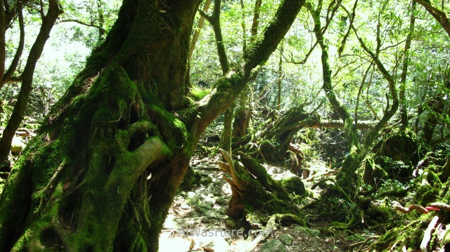
This route is, along with Yakusugi Land, the most popular in Yakushima, since it also allows to appreciate huge and ancient cedars next to the path, with a difficulty that can be overcome for most users. However, although the beauty of the trees on both routes is comparable, the forest is greener and fuller of life here than anywhere else on the island, this area being the inspiration for the film Princess Mononoke, having spent one of its main cartoonists here many hours.
It is accessed from Miyanoura. In private vehicle or public transport (550 ¥ one way) it takes about 30 minutes (for more details see TRANSPORTATION IN YAKUSHIMA).
Always open, suggested donation 300 ¥. At the entrance a pamphlet is given in which the suggested routes and their difficulty are listed:

- Yayoisugi course: easy; in about 20 minutes you reach the great Yayoisugi. The full route requires approximately one hour.
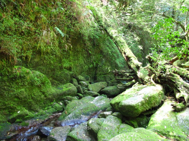
- Bugyosugi course: although it is not particularly difficult, it takes approximately 3 hours; there are at least 6 relevant yakusugis. In case of heavy rain some sections can be cut by streams.
- The last part is an extension of the second course to reach Taikoiwa Rock, a viewpoint. It is therefore the steepest area.

Shuratani Unsuikyo was the first part of my two-day trek, continuing to Jomonsugi and Mount Miyanoura summit.
First, I hiked the course to Yayoisugi, one of the largest and oldest trees on the island, 3,000 years old.

I continued on the red route until I reached point 4, the bridge, so I skipped points 2 and 3. I kept going on the yellow route. The first great cedar is the Nidai-ohsugi (5), whose base is immense, if it is not the largest in diameter of the island I do not know which one can be. It is partially covered by other trees and moss and is one of my favorites.


We continue through a beautiful forest, probably the greenest on the island, passing under stumps of dead trees until we reach the Sanbon-ashisugi (6), another cedar held on 3 legs after having disappeared the tree stump on which it grew.

Its neighbor Sanbon-yarisugi (7) is the opposite, on a very inclined main trunk three secondary trunks have grown.

Then we will arrive at Bugyosugi (8), a cedar important enough to give name to this part of the route. Its surface is practically covered by moss and other trees.

Further on there is a cedar with no name that is one of my favorites, because, although it is very low, it is held on 4 legs.

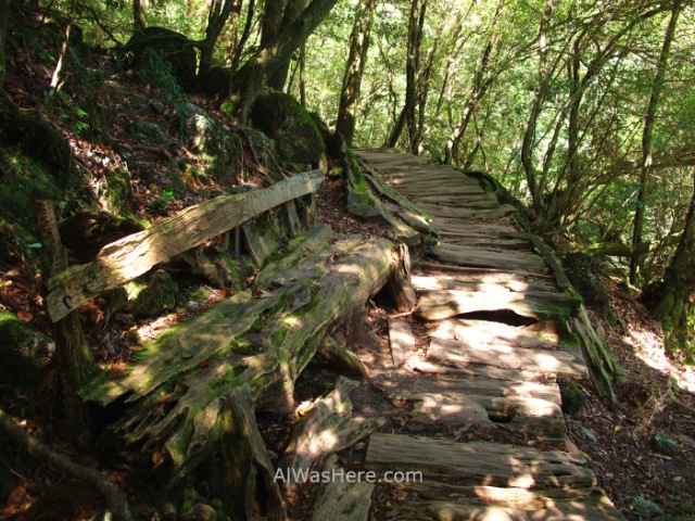
The path continues along dirt tracks that alternate planks completely reincorporated into nature, and it is not surprising that this part was the main inspiration for the forest of Princess Mononoke. We will pass under 3 beautiful cedars that are supported on two legs, very different from each other. The first one has no name, although it is my favorite because it is so slender, the following are the Nidaikugurisugi (9), where we probably have to bend down to pass, and finally, already starting the route number 3, is the largest and imposing, the Kugurisugi (11), which has the same name as the last great cedar of Yakusugi Land.


Immediately afterwards, there are toilets and drinking water. The road continues through the magnificent forest passing by another huge cedar, the Nanahonsugi (12); its name means “7 trees”, since the main trunk disappeared and from its stump 7 secondary grew so straight and together that from a distance they look like one, although currently only 5 of them survive.

The final point is a viewpoint, called Taikoiwa Rock (15), from which you get good views of the mountains of the island on a clear day.

ARAKAWA TRAIL, JOMONSUGI, MOUNT MIYANOURA AND YODOGAWA TRAIL
Arakawa trail starts at a branch of the road that comes from Anbo before getting to Yakusugi Land, there are restrictions to access in high season (see TRANSPORTATION IN YAKUSHIMA). In my case, I connected with this path after touring the Shuratani Unsuikyo. It took me approximately 2 hours to get to the connection, carrying a 10 kg backpack.

Unfortunately, when choosing this route I missed the first part of the trail, which has a point of interest, the old abandoned lumber town of Kosugidana, but you can not walk everywhere…
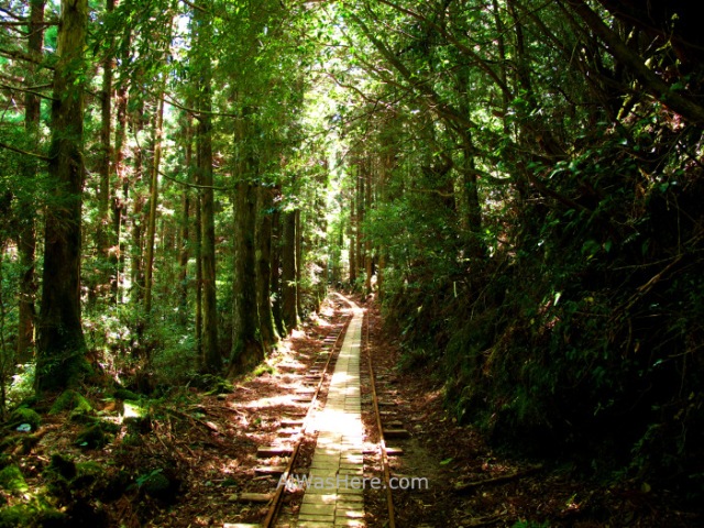
Most of the trail runs along the old restored railway tracks, a total of 8 km from the start of the trail (Arakawa Tozanguchi) and turned into a path, or about 3 km from the connection with Shiratani Unsuikyo; it kind of charming. I spotted deer, and although the monkeys are supposed to abound, I did not see any.


Very close to the end of the railway there is a detour through a wooden staircase, which is the beginning of the Ohokabu Trail. The path becomes very steep as we continue, there are sections of wooden stairs in good condition.


An exciting place is Wilson Stump, a gigantic hollow stump of 32 meters in circumference (double that of the current major in all Japan, the famous Jomonsugi), whose interior is bigger than the bedroom of a house, in which it has even been placed a small altar. It is estimated that the tree, cut 400 years ago, should measure about 45 meters high, which would make it the highest on the island, and had an age of 3,000 years. If you look up from inside, you can see a heart shape, detail that I did not know when I was there.

The route continues very uphill, mostly on stairs and wooden boards, passing by several huge cedars.

But all are eclipsed by the desire to reach the Jomonsugi. This tree is the oldest and largest on the island, and although its exact age could not be determined by the need for aggressive methods to know it, it is very likely that it will be determined soon, since this forest elder died a few years ago, although luckily decades will pass until its trunk disappears. It is estimated to be between 2,200 and 7,000 years old. Its ashen color in comparison to the other cedars back in 2013 seemed to presage its imminent death, the others are covered in moss and other trees, which do not survive in a trunk without life. The tree is protected by a fence and the public is not allowed to approach, which is disappointing, since after having seen so many magnificent cedars from so close, from 20 meters the Jomonsugi does not seem that big.

Most visitors will start the way back. It takes at least 9 hours to get to the Jomonsugi and back. We will continue uphill to one of the two mountain huts, the Takatsuka (restored in 2013, capacity 20 people), very close to the Jomonsugi, or the newest, largest and most remote Shin Takatsuka (1 km from the previous, capacity 40 people), in which I stayed, since the first one was full. Both are wooden and basic; camp stoves are allowed. Staying in one of these shelters guarantees having photos of the tree without the bulk of tourists, who are concentrated at noon and early afternoon, since at that time they still have at least 4 hours on the way back. In mid-April the temperature up there was 0ºC.

The next day I continued the route to the top of Mount Miyanoura. The section is complex, very steep, sometimes requiring the use of ropes to continue. After this peak, the path continues on the ridge to some more peaks, among them the tops of mounts Kurio, Okina and Anbo. A short distance from the main road there are detours to the tops of the Kuromi and Nageshi mounts.


Once we pass the last peak, there are three possible ways down:
- To the east, the Ishizuka trail, which leads to the refuge of the same name and connects to Yakusugi Land.
- To the south, Yudomari path, which leads to the town of the same name on the coast.
- And to the southeast, Yodogawa trail, the one I took, to the hut of the same name.
In this area there are no large trees and although it is beautiful, it is somewhat monotonous compared to the rest of the route.


When arriving at the hut we have two possibilities:
- To the south, Onoaida trail, to the town of the same name, on the south coast, famous for its hot springs. It is the most logical and usual continuation of the route, and the one made by the majority of hikers.
- Or continue on the road, what I did. I thought I had had enough forest, especially when I was going to Yakusugi Land the next day. Next to the road there are several large yakusugis. After about an hour of walking from the hut, we will arrive at Kigensugi, one of the oldest and most impressive cedars of the island, which we already refer to in the Yakusugi Land section. From here I took the bus back to Miyanoura.

MORE IN YAKUSHIMA:
<WHEN TO GO, WHERE TO SLEEP AND EAT TRANSPORT>
∇ Destinations / ∇ Asia / ∇ Japan / ∇ Kyushu / ∇ Kagoshima / ∇ Yakushima

Pingback: TRANSPORT IN YAKUSHIMA – Al Was Here
Pingback: YAKUSHIMA – Al Was Here
Pingback: RUTAS DE SENDERISMO EN YAKUSHIMA: YAKUSUGI LAND, SHIRATANI UNSUIKYO Y ARAKAWA TRAIL (JOMONSUGI) – Al Was Here
Hi, how many days do you suggest to stay in yakushima to hike at least the main trails of the island? thank you
LikeLike
Hello, if you want to hike all the three main trails you should spend at least 2 days and a half. You’ll need two days for Shiratani Unsuikyo + Arakawa Trail + Miyanoura summit, and then half day for Yakusugi Land, although if you don’t have time, you can skip Yakusugi Land, it’s beautiful but it’s more or less the same landscape. Enjoy.
LikeLike
Pingback: YAKUSHIMA: WHEN TO GO; WHERE TO EAT, SLEEP AND GET EQUIPMENT; PROBLEMS – Al Was Here
Pingback: YAKUSHIMA (屋久島) – Al Was Here