
GENERAL INTERESTING FACTS
- Location: in Juan de Fuca Provincial Park, south coast of Vancouver Island, British Columbia, Canada.
- Distance: 47 km.
- Difficulty: moderate-severe.
- Open 365 days a year, although campsites are not conditioned during the low season. High season is during summer months (from June to September). Out of this time, climatic conditions can be really hard, with important wind, cold, rain and surf.
- Hikes: distances may seem short, but we must bear in mind that the terrain is rugged, and although the overall difference in level is low, accumulated is important, since there are frequent small ups and downs. Being an area with lots of rain and humidity, the path can be slippery. To this we must add that we must carry all our food and equipment for 4-5 days. Most hikers perform it in 4, although there is always an ultratrailer that goes all the 47 km at a time. Reference points are:
- China Beach to Bear Beach: 8.7 km, moderate difficulty.
- Bear Beach to Chin Beach: 11.9 km, the hardest part.
- Chin Beach to Sombrio Beach. 8.3 km, difficult.
- Sombrio Beach to Parkinson Creek. 8 km, moderate. There is no camping area, so you have to stop before arriving (Little Kuitshe Creek) or after (Payzant Creek).
- Parkinson Creek to Botanical Beach. 10 km, moderate.

RECOMMENDATIONS
- There is no where to stock up. All food must be purchased before starting the trail, in Port Renfrew, Sooke or Victoria. Garbage can be left in containers at the access points to the road.
- Since we have to carry everything we need, and given the orography and climate in the area, it is essential to have a good physical condition and be well equipped.
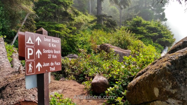
- Along the way there are information panels, and there is a post with an orange mark every kilometer.

ACCOMMODATION
The only possibility is to camp in the areas designated for this purpose:
| Campsites from east to west | Location | Access to main road |
| China Beach | Forest | Yes |
| Mystic Beach | Beach | 2 km east (China Beach) |
| Bear Beach | Beach | No |
| Chin Beach | Beach | No |
| Sombrío Beach | Beach | Yes |
| Little Kuitshe Creek | Forest | 4 km east (Sombrio Beach) and west (Parkinson Creek) |
| Payzant Creek | Forest | 4 km east (Parkinson Creek) |
- None have electricity nor running water.
- They cost 10 CAD $ per person per night. Self registration to pay and occupy a spot. You can pay in two ways:
- Before starting the route on the official website.
- At the entrance of each camping area there is a metal box with envelopes in which there is a form that is filled in indicating the data and number of people; then money is placed in it (cash only, there is no change) and it is dropped in a mailbox, keeping a copy. For campsites that are intermediate in some parts of the route, you have to pay at the beginning of it in similar boxes.


- The toilets are latrine type, all have soap / hand sanitizer without water and toilet paper. In all there are hermetic containers to leave the garbage and food at night away from the tents, to prevent bears from approaching to them.

- In general, fire is not allowed, but gas stoves are allowed for cooking.
- The only truly camping is China Beach:
- Do not confuse the campground with the recreational area on the beach of the same name, very close to each other.
- It has drinking water tanks.
- It is the largest and most organized, and in its spots fit several tents, along with cars and large motorhomes.
- It is the only one that admits reservations from May 15 to September 3 (the rest of the year is closed, being the only one that closes in low season), for 66 of its 79 places. You can book online in this link. The last 13 are assigned first come first served, so you have to try to arrive as early as possible, approximately between 8 and 9 a.m., to occupy a free space. In our case, we did not do the linear route, the first night we stayed in Jordan River, just before arriving at the Park.

Breakfast in Jordan River We got up and arrived early at China Beach. To know which places are available, you can ask the Ranger or inspect them one by one. Available ones are indicated as such in a pole at the entrance, with a number.


- The rest should be considered as campsite areas:
- You have to treat the water, either by boiling it, or by using water purification tablets or filters.
- The places are occupied in order of arrival. In each one only one tent fits.

- Beach campsites are usually very exposed to the ocean, which makes the nights harder than those of the forest.

Camping spots in Mystic Beach, with no more protection than wasted wood
- At the end of the trail there is accommodation in the village of Port Renfrew.
TRANSPORT
Being a linear route, a bus service has been arranged. The company is West Coast Trail Express Bus. It covers the route of Juan de Fuca and West Coast Trail, from Nanaimo and Victoria:
- Available between May 1 to September 29.
- Frequency: once a day in each direction.
- Price: 55 CAD $, 60 if you go to Victoria.
- Route: Nanaimo, Victoria, Sooke, Jordan River, China Beach, Sombrio Beach, Parkinson Creek and Port Renfrew. It is the same bus that continues towards the West Coast Trail.
- The buses can be 24, 28 or 30 seats.
- They stop on the road BC 14.
- Tickets can be booked on their website or pay directly to the driver. If we do not reserve, we risk that it will be full and we have to wait for the next day.

If you do not intend to use the bus, the only option is your own vehicle. We choose to drive to the access points and make one-day, round-trip hikes.
DANGERS
- In case of accident or emergency, mobile phones will have no signal in almost the entire route.
- Climatic conditions can be harsh and changing in this area.
- Falling trees or branches are frequent.
- Tides. Certain sections of the route are impossible to hike in high tide, they are indicated on all maps and panels: near Bear Beach, Chin Beach and Sombrio Beach.

Detail of the official map where buoys are indicated and also the spots where the trail would be cut off in high tide The areas where the path connects to the beach are marked with red buoys, which at low tide are hanging, being easily identifiable.

Buoys hanging in low tide near the entrance of the path into the forest Some have alternative routes through the forest but most do not. The tide has an approximate difference of up to 3 meters, so it is essential to check the tide tables daily before starting each section of the route. They are available at the tourist information points of Port Renfrew, Sooke, and on the boards at the start of each section of the trail. We must add an hour between May and October for the change of time for energy savings.
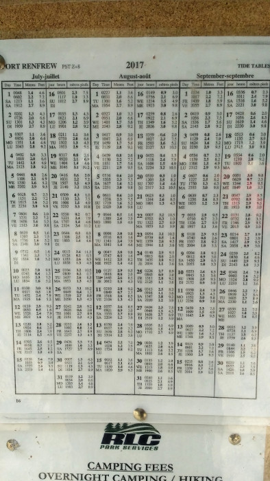
Tide table on an information pannel It should be taken seriously, we have met people who have had to cross stretches with their backpacks on their heads and water up to their necks, and some who had to wait up to 6 hours to continue.
- The humidity of the area and the path of the road along stretches of beach at low tide makes this a slippery route, with abundant muddy areas.
- Bears. Juan de Fuca is the natural area with the highest concentration of black bears and pumas in the country. Nor should we underestimate the presence of these animals that cause so much fascination. The desired encounter with a bear may not be so much once it occurs in the midst of nature, and I speak from my own experience. On the stretch between Parkinson Creek and Sombrio Beach, being the first of our group of 3, at the end of a sharp turn I bumped into a black bear, in the middle of the trail and only 10 meters away, with its young, which it makes it even more dangerous. At that time you do not know if your body has become petrified or your mind is going very fast. Luckily, after almost 3 weeks in Canada, my mind had very well internalized the instructions, move away slowly without losing eye contact, trying to look as big as possible. 15 minutes it took us to move forward, as the cub came to climb a tree to escape from us, and then it could not go down. 20 minutes after they left, we spotted them again about 200 meters walking along the rocks of the coast.


- In parking lots there are frequent thefts in vehicles.
MORE IN JUAN DE FUCA TRAIL:
THE ROUTE>
∇ Destinations / ∇ Canada / ∇ British Columbia / ∇ Vancouver Island / ∇ Juan de Fuca

Pingback: INFORMACIÓN PARA EL JUAN DE FUCA MARINE TRAIL: ETAPAS, CAMPINGS, PELIGROS, TRANSPORTE – Al Was Here
Pingback: JUAN DE FUCA MARINE TRAIL – Al Was Here
Pingback: JUAN DE FUCA MARINE TRAIL: THE ROUTE – Al Was Here