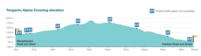
The Tongariro Alpine Crossing is a 19.4 km (12 miles) trek through a stony and arid terrain for the most part, not suitable for beginners, even less if the weather conditions are adverse. It is by far the most visited and famous route in Tongariro National Park.
- It is best to start the route from the west, in Mangatepopo car park, and finish north, in Ketetahi car park, since the first one is at a higher altitude. This way, the cumulative drop uphill will be just over 800 m, and the cumulative drop downhill of about 1200 m.
- You can optionally climb to the top of Mount Ngauruhoe, to that of Mount Tongariro, or both, but the signs were removed at the request of local Maori in 2017 because they are considered both sacred mountains. The trail itself is not prohibited but it is not recommended by the rangers.
- The route is usually done in about 7 hours, not including climbs to the summits.
- There are toilets every 2 km approximately.
- It is not allowed to spend the night on the route, except for those who are granted permission to use the mountain shelters.
- Dog access is not allowed.
To see a more complete profile of the route, I leave a wikiloc link, which I hope I can soon replace with that of my cousin Dani, for whom I write this article. I would put my own route, but in 2004 we didn’t have these poshy things yet.
https://es.wikiloc.com/rutas-senderismo/tongariro-alpine-crossing-22759426

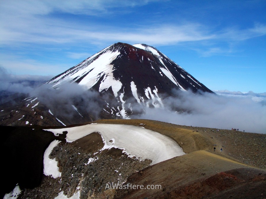
The beginning of the route in Mangatepopo car park is relatively flat, starting at 1120 m altitude. In this first part there are low yellow bushes and some sections are covered on wooden planks. At 1.5 km and after an ascent of 70 meters we will find Mangatepopo Hut, where those who hike the North Circuit spend the night. If the clouds allow it, we can contemplate magnificent views of Mount Ngauruhoe and imagine it covered with lava and fire as in the Lord of the Rings movies to feel like Frodo or Sam; Point out that there have been no eruptions since 1975, they were added to the film through special effects. On the contrary, almost certainly, on the top there will be snow at any time of the year.

The route maintains a certain ascent up to 1390 m in Soda Springs, we should take approximately 90 minutes walking. In Soda Springs the first relevant slope begins; It will take almost another hour to reach the South Crater, although it is not a true caldera, it is called that because it looks similar, but it is so flat that we will not realize that we are in it until we see it from above. The road runs through the center of it, with Mount Ngauruhoe on the right.


About halfway we can decide if we climb to the top of Mount of Destiny to throw the ring or enjoy the scenery. The ascension represented 2 more hours time when it was openly allowed and signposted. I did not hike it because I had enough jetlag and in 2004 there were not as many minibuses as now, each company only had one minibus a day and I thought it might not arrive on time. Now that I know that the climb is not advised, and that it is most likely that it will soon be formally prohibited, I regret not having tried. Since the signaling was withdrawn in 2017, I leave here a recent track of a user, from February 2019; in his photos you can see how the top is covered with snow despite being late summer.
https://es.wikiloc.com/rutas-senderismo/tongariro-crossing-with-ascent-of-ngauruhoe-32963530
Whether we have climbed the Ngauruhoe or not, the path continues along the South Caldera and where it ends, the second and last significant ascent begins, to the edge of the Red Crater, named for its ocher color related to iron ore, this being the point highest on the official trail, at 1886 m altitude.


Just before reaching the edge of the Red Crater, you can take the turnoff that goes up to the top of Mount Tongariro. Although it attracts less hikers for being the lowest peak, from it you can see an excellent view of Mount Ngauruhoe in the first place and Mount Ruapehu in the background on your right. Round trip is 3 km, it usually takes an hour and the slope up is only 100 meters drop. As of November 2019 there is no climbing restriction, so the signage should be on, but just in case, I leave a new Wikiloc link with a user who climbed in April 2019:
https://es.wikiloc.com/rutas-senderismo/tongario-summit-alpine-cross-35436497

The next point of interest are the three small Emerald Lakes, a short distance from the edge of the crater. They are very photogenic.

The descent is quite pronounced, and continues to the Blue Lake, larger than the previous ones.


At this point we are approximately halfway down the trail, and the bad thing is that we have already seen everything that is better considered. From here begins an abrupt descent at the beginning but soon uniform, overlooking Rotoaira in the first place and Taupo lakes in the background; the view is quite beautiful, but it ends up becoming monotonous since it hardly changes during the 2 hours we have left.

We will pass through Ketetahi Hut. Nearby there is a hot spring that is owned by the Maori in the area; It is closed to the public since in 1990 a tourist bathed in them and died scalded.
The surrounding landscape from this point does vary, since when descending, the vegetation begins to appear, at first low, golden and compact shrubs reminiscent of a blond meadow; we will find the first low flow streams, with rocks dyed red and yellow by iron and sulfur minerals, and some fumaroles.


Gradually the lustrous green vegetation of the rainforest, so frequent in New Zealand, begins, with small waterfalls (the Ketetahi Falls) and live streams. Finally we will arrive at Ketetahi parking lot where our shuttle will pick us up.

WHAT TO BRING
You have to go well equipped to the trail, since there is no conditioning or provisioning once we start:
- We must bring all our food and water. The water from the few streams near the end is not drinkable because it is rich in sulfur. Since even in summer it is likely to be cold, we usually do not need more than two liters.
- The terrain is very abrasive, mountain footwear is recommended, if possible waterproof, due to the possibility of rain.
- For this reason, it is convenient that all clothing be windproof and breathable, at least the jacket.
- Cap and sunscreen in case the sun shines.
- Toilet paper, because although there are latrines on the route, they do not provide it.
WHEN TO GO
The volcanoes in Tongariro National Park are the most significant elevation that the winds find in their passage through the North Island; Rains are very frequent all year. Even if it does not rain it is very likely that the summits or much of the plateau are covered with clouds.
The best time to hike the Tongariro Crossing is summer (end of December, January, February and beginning of March), although it is possible that clouds or rain make an appearance for days, so if the forecast predicts bad weather, for those who start and finish their trip in Auckland (the vast majority of travelers) it is recommended to continue the trip and try the visit when back. For many summers, the summits of the two volcanoes are completely or partially covered with snow. In winter it becomes a high mountain trek, and requires crampons, ice axes and snowshoes. The temperature can vary dramatically, even on the same day. The highs are 25 ° C in summer and the minimums are up to -10 ° C in winter.
The trek is not crowded even in summer, so this should not be a factor that restrains us from trying in high season.
TRANSPORTATION TO THE ROUTE
In both National Park Village and Whakapapa you can hire minibuses that leave the hiker in Mangatepopo car park in the morning and pick you up at Ketetahi in the afternoon. Shuttles will not come out if the weather forecast is unfavorable the day before, and there are usually no services from mid-May to mid-October. Some of the minibus companies are:
- National Park Shuttles. 1 a day, 45 NZ $.
- National Park Backpackers or Tongariro Crossing shuttles (they are the same company). 5 a day, 40 NZ $.
- Tongariro Track Crossing. NZ $ 40. Their website is not very reliable.
- Summit Shuttles. 4 a day, 40 NZ $.
All these companies provide minibuses if we want to make any of the other circuits, whether the North Circuit, such as the Round the Mountain, as well as offer other excursions in the area.
However, there are few who travel from Taupo, as was my case. If we want to go directly from Taupo to Tongariro Alpine Crossing without going through other areas of the national park, our only option is a Tongariro Expeditions shuttle that leaves at 5:20 am, costs NZ $ 70 (round trip) and takes 90 minutes to arrive.
To avoid congestion in the parking lots and to promote that visitors do not climb Mount Ngauruhoe, in high season the maximum allowed parking time is 4 hours. In case of exceeding, we will not only be fined, but our vehicle could be immobilized and we would be forced to take a shuttle back.
MORE ON TONGARIRO NATIONAL PARK:
INFORMATION IN TONGARIRO: SITUATION, OTHER ACTIVITIES, HOW TO GET THERE, WHERE TO SLEEP AND EAT>
∇ Destinations / ∇ Oceania / ∇ New Zealand / ∇ North Island / ∇ Tongariro National Park

Pingback: PARQUE NACIONAL TONGARIRO: EL TONGARIRO ALPINE CROSSING – Al Was Here
Pingback: TONGARIRO NATIONAL PARK – Al Was Here
Pingback: INFORMATION IN TONGARIRO NATIONAL PARK: SITUATION, ACTIVITIES, CLIMATE, HOW TO GET THERE AND ACCOMMODATION – Al Was Here